 The Voice – Fuerteventura Keep up to date in Fuerteventura with The Voice Magazine
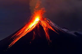
ISLANDS OF FIRE
An article by Bernie Power with The Voice
Fuerteventura is an island of elements, and the one responsible for its conception is fire.
We live on a group of islands formed by volcanoes, and the evidence of that is still very clear. The peaceful mountains you see today were once alive and spewing acidic gas, ash, molten lava and rocks, hundreds of feet into the air, creating the oldest canary island on which we all now live. If we were around 20, million years ago, we would have witnessed two volcanoes that rose from the Ocean. Then some years later we would have watched another volcanic event occur, which joined the two together, forming this one strangely shaped island that we now call home.
DESTRUCTIVE & DESOLATE
A quick visit to the Timanfaya National Park on neighbouring Lanzarote, will give you a firsthand view of not only the kind of destruction that a volcano can cause, but will also demonstrate the kind of heat that it generates, a reminder that the magma underneath us is still flowing, the tectonic plates are still shifting and that the earth is still moving and growing. But although they appear to decimate anything in their path, life does return.
FIVE MONTHS OF FIRE
Timanfaya last erupted in September 1730, and blew for 19 days. It then continued to leach molten lava from smaller volcanic cones, for a further five months. The lava flows only stopping once they reached and were cooled by the ocean. Villages were destroyed and homes were evacuated, but visit the island now and there is an abundance of life, new towns and a thriving community which makes its living from the volcano that once almost caused its demise.
MODERATE MAGNITUDE
Although it has been around 5 to 7,000 years since Fuerteventura has seen any kind of volcanic activity, but the same cannot be said for the neighbouring island of El Hierro. This time last year we reported on a seeming new volcano in the making. Villages were evacuated, planes were diverted and all fishing practices cancelled as a sea of magma appeared in the ocean and debris and water was ejected up to 60 foot in the air. At that time the scale measured a magnitude quake of 4.3.
EARTHQUAKE SWARM
A year later and it is back in the news again. At 5.46pm local time on the 27th December 2013, the National Geographic Institute reported a swarm of magnitude earthquakes reaching between 5.1 and 5.4. These are the highest recordings to date and although sound worrying, are only deemed a moderate quake by scientists, indicating purely that magma is moving around under the earth’s surface. Reports show that a total of 550 earthquakes rattled the island in just three days and that the epicenter of the quake began just 15km below the surface. This prompted the volcano monitoring agency, to raise the Volcanic Eruption risk level to yellow (Indicating that there is increasing activity but that no eruption is imminent). The same status was applied in June 2012.
MAGMA RISING
Seismologists certainly have plenty of interesting data to analyse, as reports also show that surface levels between El Pinar and La Restinga on El Hierro, swelled by around 7cm in just one week. Apparently caused by magma rising underground, fracturing the rock and swelling the surface as the hot rock pushes its way upwards. I am guessing this isn’t the last we will hear of El Hierro and who knows, maybe this really is the beginning of a new fire island in the making!

